Principles of Meteorology
by David Straton
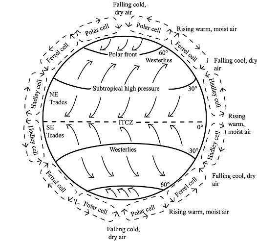
This document is not established expertise on the subject. It is an attempt by a self-taught student to bring together ideas about meteorology as part of a preparation for cruising in the South Pacific. Weather can be best understood by thinking at several levels: global, synoptic, intermediate and local. Global Over the equator, maximum sunlight lands. The air is heated and rises. Over the poles, minimum sun lands. The air is cold and sinks. If the atmosphere were infinitely deep, there would probably be a single circulation, rising at the equator and sinking at the poles. In fact, the circulation involves three cells, rotating like cogs in a clock. Cold air sinks over the poles, and moves towards the 60° parallel in the Polar cell, where it rises. Also rising at the 60° parallel is air from the Ferrel cell, which rotates in the opposite direction, sinking at the 30° parallel, where it meshes with the sinking air from the Hadley cell. Because of the Coriolis effect, (see below) the winds are all bent to the right in the northern hemisphere, and to the left in the southern hemisphere.
The complete diagram summarizing atmospheric circulation. Note that rising warm, moist air results in a low pressure zone and descending cold, dry air results in a high pressure zone. These zones of high and low pressure along with the Coriolis force create the major wind belts. Note: The Hadley cell extends from the equator to about 30 degrees N and S latitude, the Ferrel cell extends from about 30 to 60 degrees N and S latitude and the Polar cell extends from 60 degrees latitude to the poles (90 degrees N and S latitude). There is a good UCSD Calspace website here. Coriolis Effect The
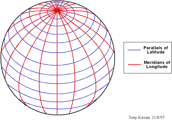
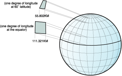
Coriolis Effect One way I have found helpful to think of the Coriolis effect is to imagine the Earth as consisting of two nine-lane motorways, one in the northern hemisphere and one in the southern. Whereas the meridians of longitude are all the same length (approx 40,000km), the parallels of latitude vary.
Since the Earth rotates once every 24 hours, it follows that the rotational speed in km/h varies with different latitudes.
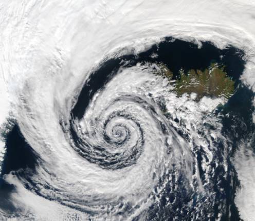
So imagine yourself in the outside lane of this 9-lane motorway, on the Equator, hooning along in an easterly direction at 1,670 km/h. The car in the lane inside you, in the northern hemisphere, is going slower, and the ones inside that, slower still. Now imagine trying to throw a tennis ball from one car to another. You throw it directly out of the window, at 90° to your direction of travel. The ball has your easterly velocity, so tends to pass in front of the car inside you. It appears to swerve to the right, or to the east. (1) A ball thrown from a car in one of the slower tracks to a faster car appears to swerve to the right, or the west, and pass behind the faster car. (2) The Coriolis effect is a little more difficult to explain for objects moving in an east-west direction. Imagine throwing your tennis ball directly east from your moving car on the 40° northern parallel. Your car continues round the track, a 'small circle' with its centre a point on the axis of the Earths rotation, between the equatorial plane and the Pole. The ball continues its tangent from where you threw it, but follows a 'great circle' determined by gravity operating towards the centre of the Earth, on the equatorial plane. To you, in your speeding car, the ball appears to veer to the right. Thus, when wind rushes from a high pressure zone towards a lower pressure, in the northern hemisphere it tends to swerve right, and get into an anticlockwise spiral. See this anti-clockwise Low Pressure system in the northern hemisphere.
The opposite occurs in the southern hemisphere, with the Coriolis effect causing wind direction to bend leftwards, and depressions or cyclones to rotate in clockwise direction.
Cyclone Fay over Western Australia on March 25, 2004.
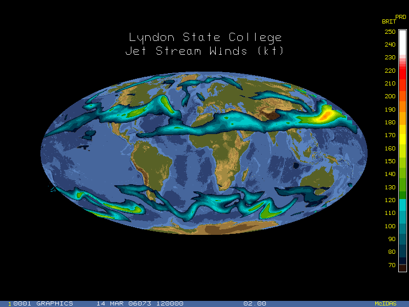
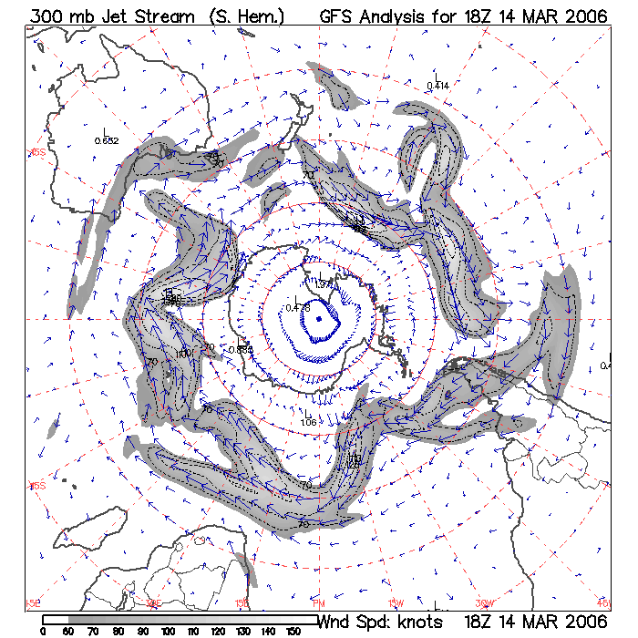
Jet Streams The three cells, Hadley, Ferrel, and Polar, (sometimes collectively called the Hadley Cells) have zones of interaction near the 30° and 60° parallels. These are places where warm and cold air meet. In the higher levels of the atmosphere about 12 kilometres high, in the grooves between the Hadley cells, strong narrow currents of wind flow from west to east. These are the jet streams.They average 50 knots and sometimes reach more than 200 knots. The one at 30° is called the 'subtropical jetstream' and the one at 60° the 'polar jetstream'.
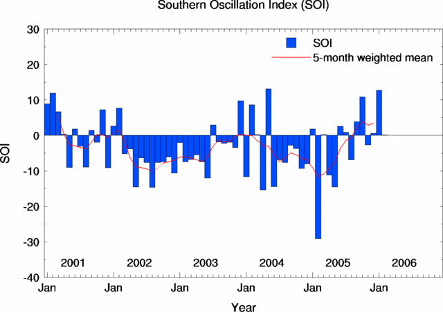
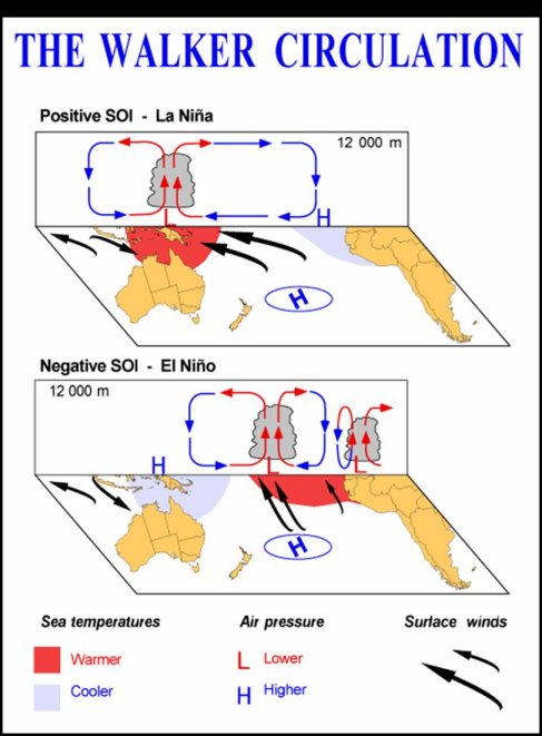
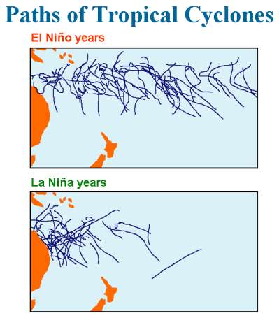
Southern Oscillation Index The Southern Oscillation Index (SOI) is calculated from the monthly or seasonal fluctuations in the air pressure difference between Tahiti and Darwin. Sustained negative values of the SOI often indicate El Niño episodes. These negative values are usually accompanied by sustained warming of the central and eastern tropical Pacific Ocean, a decrease in the strength of the Pacific Trade Winds, and a reduction in rainfall over eastern and northern Australia. The most recent strong El Niño was in 1997/98.
Positive values of the SOI are associated with stronger Pacific trade winds and warmer sea temperatures to the north of Australia, popularly known as a La Niña episode. Waters in the central and eastern tropical Pacific Ocean become cooler during this time. Together these give an increased probability that eastern and northern Australia will be wetter than normal. The most recent strong La Niña was in 1988/89; a moderate La Niña event occurred in 1998/99, which weakened back to neutral conditions before reforming for a shorter period in 1999/2000. This last event finished in Autumn 2000.
|
